
All images © by Roberto Piperno, owner of the domain. Write to romapip@quipo.it.
Notes:
Page revised in September 2024.

All images © by Roberto Piperno, owner of the domain. Write to romapip@quipo.it.
Notes:
Page revised in September 2024.
 Civitavecchia, Allumiere and Tolfa

Clickable Map of the itinerary (in blue); red dots: towns covered in this section; green dots: towns covered in other sections; green line:
border between the Provinces of Viterbo (above) and Rome (below)
This itinerary starts from the Tyrrhenian Sea (Civitavecchia) and it ends near the River Tiber (Civita Castellana). It crosses an area of extinct volcanoes, the craters of which house lakes. Most of the towns shown in this section were founded on a little
hill at the junction of two ravines. They have a long history which includes: Etruscan foundation, Roman conquest, medieval development as independent
townships and finally inclusion in the State of the Church.
The itinerary crosses some ancient Roman roads: Via Aurelia which reached
Pisa and Genoa at Civitavecchia; Via Cassia which reached Florence, northern Italy and France at Oriolo and Sutri; Via Flaminia which reached Rimini and the Adriatic Sea at Civita Castellana.
The town was founded by Emperor Trajan as an alternate harbour to Porto to ensure a steady flow of supplies to Rome. It was called Centumcellae (one hundred rooms) because of its warehouses. The Emperor monitored the construction of the harbour from a villa on a neighbouring hill; the site retains evidence of large baths (Terme Taurine).
In 828 the town was occupied by the Saracens and its inhabitants abandoned it.
The Saracens used it as a base to attack Rome in 846, but in 848 they were ousted from Centumcellae and the old inhabitants returned and rebuilt it.
They renamed it Civitavecchia which means old town (civita=town - vecchia=old).
During the Middle Ages the importance of Civitavecchia was limited as the main port of Latium was Corneto which is
located seven miles to the north. In 1462 alum was discovered on the nearby hills of Tolfa and its mining became a very important source of revenue for the Papal State (more on this topic further down in the page). Alum was shipped from Civitavecchia and the popes improved its facilities and fortifications.
In 1508 Pope Julius II commissioned the construction of a new fortress to Donato Bramante on the southern side of the harbour opposite a medieval castle, which was destroyed during WWII.
Bramante designed a rectangular fortress with four round bastions at the corners. This design was not the state-of-the-art in Italian military architecture because the round bastions did not ensure the best protection of the walls. At Civita Castellana and Nettuno Antonio da Sangallo the Elder had already designed more effective bastions.
In the 1530s Pope Paul III ordered the construction of a massive keep which projected from the walls and ensured they were better protected. According to an undocumented tradition the keep was designed by Michelangelo and today the fortress is named after him.

Forte Michelangelo: (left) one of the four round bastions; (right) entrance from the harbour
The fortress stood at the water's edge. Its proportions, the facing of the walls with travertine and their decoration give it a very harmonious appearance (see other images of Forte Michelangelo). The image used as background for this page shows the fleurs-de-lys which decorate the keep. They were the heraldic symbol of Pope Paul III. For a very similar decoration you may wish to see the Pope's family palace in Rome.

The harbour of Civitavecchia and its northern mole with papal inscriptions and coats of arm
As Civita Vecchia was 1400 years since, so is it now. The artificial island, with its twin-towers at the mouth of the port; the long moles stretching out to meet it; the double passage, narrowed almost to a closing of the jaws; the amphitheatre of water within, overhung by the houses of the town, and sheltered from every wind - will be at once recognised. It would seem to have remained in statu quo ever since it was built by Trajan. Yet the original town was almost utterly destroyed by the Saracens in the ninth century; but when rebuilt, the disposition of the port was preserved, by raising the moles, quay, and fortress on the ancient foundations, which are still visible beneath them.
George Dennis - The Cities and Cemeteries of Etruria - 1848
Another route from Leghorn to Rome is by sea as far as Civita Vecchia, and thence by railway. This route is somewhat more expensive than the railway journey. Embarkation at Leghorn in the inner harbour. The steamers generally weigh anchor towards evening. Arrival at Civita Vecchia, and journey thence to Rome. The fortifications, built in the 16th and 17th cent., were recently restored by the French. The entrance to the harbour, in front of which lies a small fortified island with a lighthouse, is defended by two strong towers.
Karl Baedeker - Italy; handbook for travellers - 1883
Civita Vecchia is a port of not much importance, except that from here the regular steamer sails to Sardinia.
David Herbert Lawrence - Etruscan Places - Published in 1932, but based on a visit made in April 1927.
Civitavecchia is still the main ferry port from continental Italy to Sardinia, but in recent years also many large cruise ships call at Civitavecchia to allow participants to make a daily excursion to Rome.

(left) Fontana del Vanvitelli; (right) Porta Marina
In the XVIIIth century Civitavecchia became the most important port of the Papal State on the Tyrrhenian Sea, yet its activities were mainly limited to exports of alum, because imported goods reached Rome via small ships and were unloaded at Ripa Grande, the city's river harbour. The town was embellished with a fountain designed by Luigi Vanvitelli, one of leading architects in Rome at the time of Pope Benedict XIV. A few years later Pope Clement XIII opened a monumental gate in the walls which separated the town from its harbour.

(left) The modern building which stands on the site of the Arsenal designed by
Gian Lorenzo Bernini for Pope Alexander VII; (right) S. Francesco (late XVIIIth century)
In 1825 Civitavecchia became a diocese and S. Francesco, its main church, became the town's cathedral.
After the annexation of the Papal State to Italy in 1870 the importance of Civitavecchia increased because it was the port of mainland Italy which was closest to Sardinia. In the XXth century it became the port of entry for iron ore directed to the steelworks of Terni. Because of the importance acquired in the communication and industrial system of the country Civitavecchia was heavily
bombed during World War II. Nearly 90% of the buildings were so damaged that they had to be completely pulled down during the post-war reconstruction. S. Francesco was rebuilt as it was, but in a dull modern urban context.

(left) Custom-house built by Pope Clement XIII which today houses the National Archaeological Museum;
(centre) plaque celebrating new barracks built by Pope Pius VI; (right) plaque celebrating the site of the house where Henri Beyle (Stendhal), a French writer,
lived when he was French consul at Civitavecchia in 1831-1842
The inscription celebrating Stendhal speaks of his love for Italy, because he hated living in Civitavecchia. The town was not popular with foreigners.
Civita Vecchia is a place utterly devoid of interest, and in the
eyes of those who arrive at Rome by sea, is only connected
with much discomfort and an ardent desire to get away.
Augustus J. C. Hare - Days Near Rome - 1875.
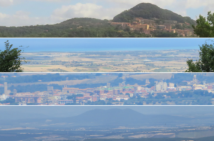
(top) View of the town; (below) views from the town: the Tyrrhenian Sea north of Civitavecchia, Corneto (Tarquinia) and Monte Soratte
In the hilly country between Corneto and Civita Vecchia, picturesquely situated in a wild district, is Tolfa, much resorted to in summer on account of the mineral baths in its neighbourhood for the cure of rheumatism, gout, and neuralgia. A little to the west of this is Aluminiera with very remunerative alum-mines. Hare
Tolfa. A town situated in the range of the woody mountains of Cervetere. It may be visited from the side either of Bracciano, or of Civita Vecchia. At Tolfa there is a great manufactory of saltpetre.
Sir William Gell - The topography of Rome and its vicinity - 1834
Allumiere was administratively detached from Tolfa in 1826.
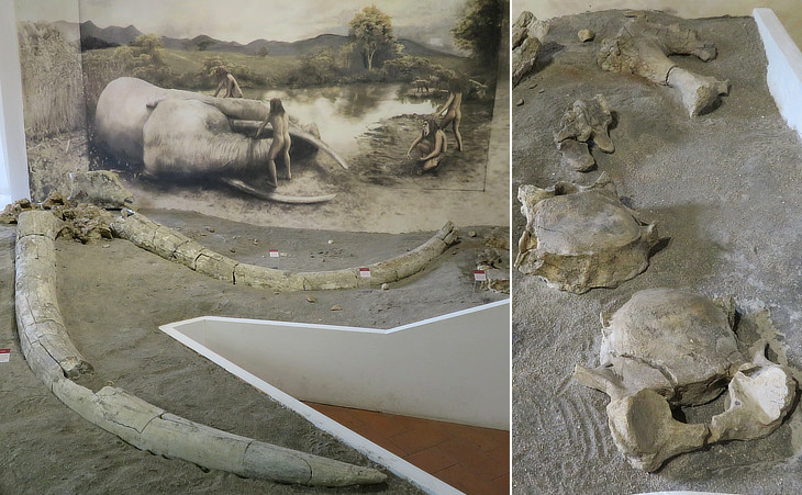
Town Museum "Adolfo Klitsche de La Grange" (*): bones of Palaeoloxodon antiquus from the site of La Ficoncella (between Allumiere and Tarquinia)
The La Ficoncella site, still only at the beginning of excavation activities, has yielded various skeletal remains of Palaeoloxodon and a few other anatomical elements of other species, such as Bos primigenius and Equus sp., in association with four stone artefacts. The stratigraphic unit, still under study, contains fauna and lithic remains which could be dated to 500,000 years ago. The site can be considered as an important source of information about the dynamics of human population and the relationship between humans and elephants during the early Middle Pleistocene in central Italy.
Similar evidence has been found near Anagni and Ceprano. See a diorama at Museo di Zoologia in Rome and elephant tusks which were found in Rome.
(*) Adolfo Klitsche de La Grange (1836-1894) promoted the first scientific archaeological excavations in the area of Allumiere.
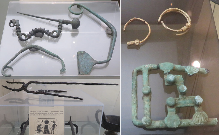
Town Museum: Villanovian (the earliest phase of the Etruscan civilization) and Etruscan bronze tools and brooches and jewels (see other exhibits at the Archaeological Museum of Civitavecchia)
It was metallurgical wealth that determined Etruria's development, urbanization and rapid rise to prosperity. They mined and processed copper, lead, iron and finished metal products for export. Cities such as Populonia were known for their iron industry, Tarquinia for the production of bronze utensils. The source of economic strength lay in their control of the mineral resources from the Tolfa Hills (west of Lake Bracciano), northward to the Colline Metallifere (the metal-bearing mountain chain) of Tuscany, where ore deposits of copper, lead, iron and tin were abundant. The objection might, however, be raised that the growth in wealth, the Orientalization and the Hellenising of Etruria appear to be earlier and more marked in the cities of the south than in the actual metal-rich area further north. But such a statement may perhaps be premature: for on the one hand there are traces of ancient and important mineral resources in the south, in the Tolfa hills between Cerveteri and Tarquinia, and on the other hand discoveries at Populonia have revealed in the north too an early and rich Orientalization movement. The answer might be that, at first, the exploitation of the great natural wealth of Etruria was of most benefit to the centres that specialised in brokerage - centres of early political and cultural attainments in direct contact with the great Mediterranean trade routes, such cities as Cerveteri or Tarquinia. Lawrence
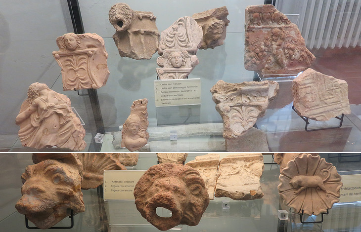
Town Museum: Terracotta fragments which decorated Roman rural villas near Allumiere
During the IIIrd century BC the territory of Allumiere was acquired by the Romans who founded several farms which had a residential section (see that of Villa dei Volusii in the Tiber Valley) and in some instances also a mining activity. The exhibits mainly come from a Roman villa called La Fontanaccia after an old trough. It was made up of four large terraces and it had facilities for storing and processing food.
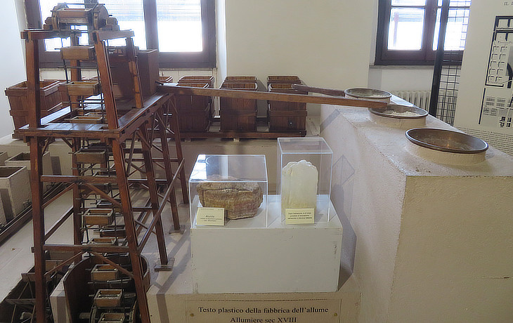
Town Museum: Alum processing model in the XVIIIth century; in the foreground the mineral (alunite) and the final product
Alum, hence Allumiere, is a double sulphate of aluminium and potassium, which is used in paper manufacturing, tanning of hides and dyeing. In the past the limited development of chemistry made the ores of natural alum as profitable as gold mines. The process required smashing and burning the raw material and then repeatedly soaked until the pure alum deposited in boxes. The exploitation of the mines took place mainly in the open air, tunnel exploitation was introduced only in the last years of the activity, to reduce the costs of the extraction phases. Open-air exploitation has modified the shapes of the territory by opening chasms and producing accumulations of landfill material but the impact that these activities have had has been partially hidden by the coppice forests and beech and chestnut woods which today characterize the landscape around the town.

(left) Palazzo delle Allumiere; (right) clock indicating the "Italian Hour" and iron weathervane with keys, the symbol of Camera Apostolica
The Genoese held the monopoly over the alum trade for centuries, but in 1455 Sultan Mehmet II conquered Foca in Asia Minor where the Genoese mines of alum were located. The Ottomans imposed heavy duties on exports and the discovery of alum fields at Tolfa was welcomed by all Christian nations, which feared to lose access to this important mineral. Usually the Papal State did not run the mines directly, but gave them to a concessionaire in return for a fee and this was often a way to favour a friend or a relative of the pope. Agostino Chigi was one of the first concessionaires. He made such profits that he built La Farnesina, a villa which was decorated by Raphael and other famous painters.
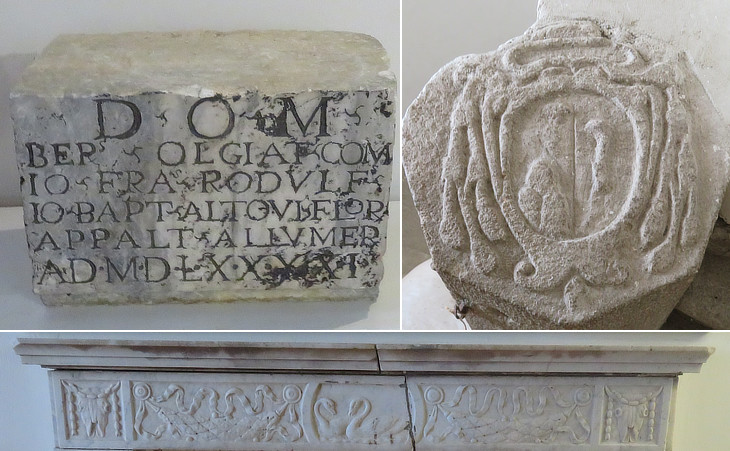
Palazzo delle Allumiere: (above-left) 1591 inscription with the names of the concessionaries; (above-right) coat of arms of a prelate, most likely a Bishop of Sutri; (below) detail of a marble mantlepiece
The town of Allumiere was founded to house the miners and the administrative offices, so its main building is not a town hall, but the palace where managerial and accounting activities were performed. It was completed in 1580. In 1590 the exploitation of the mines was entrusted to Giovanni Francesco Ridolfi, Bernardo Olgiati and Giovanni Battista Altoviti, three bankers. The Altoviti had a palace near Ponte S. Angelo and a villa in Prati di Castello.
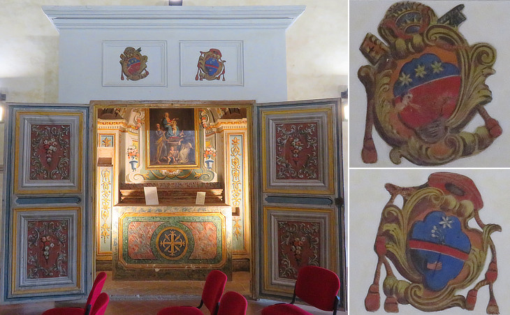
Palazzo delle Allumiere: (left) altar inside a cupboard designed by Francesco Navone in 1777; (right) coats of arms of Pope Pius VI and of Cardinal Guglielmo Pallotta
Guglielmo Pallotta was appointed Treasurer general of the Apostolic Chamber in May 1773 by Pope Clement XIV. In this capacity he was also responsible for the management of the alum mines. He was made cardinal in 1777 by Pope Pius VII and he decided that Palazzo delle Allumiere needed a site where he and possibly the Pope could celebrate Mass or attend other religious ceremonies. Rather than building a chapel he placed a covered altar in the main hall of the building.
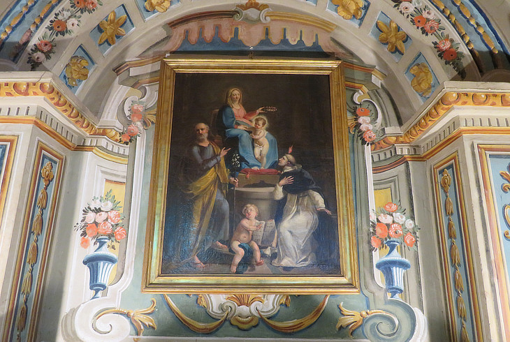
Palazzo delle Allumiere: altarpiece by Pasquale Porfiri portraying the Virgin of the Rosary, St. Joseph and St. Vincent Ferrer; decoration by Carlo Iacchini
We know very little about the painter Pasquale Porfiri, apart from a reference to his house in a note by Goethe:
Rome, Dec. 1, 1786.
Moritz is here, who has made himself famous by bis
"Anthony the Traveller" and his "Wanderings in England". He is a
right down excellent man, and we have been, greatly pleased with him. (..) December 8, 1786.
In the evening poor Moritz, as he was riding home, broke his arm, his horse having slipped on the smooth
Roman pavement. This has
plunged our little domestic circle in sad affliction. (..) January 6, 1787. I have just come from Moritz, whose arm is healed, and loosed
from its bandages. It is well set, firm, and he can move it quite
freely. What during these last forty days I have experienced
and learned, as nurse, confessor, and private secretary to this
patient, may prove of benefit to us hereafter.
J. W. Goethe - Italian Journey - Translation by Charles Nisbet
A note in Goethe's diary says that Moritz stayed at the house of Pasquale Porfiri who lived in that of the architect and metal caster Giuseppe Valadier at the corner of Vicolo d'Alibert, today Via del Babuino. On the third floor was the room where Goethe spent many days assisting Moritz.
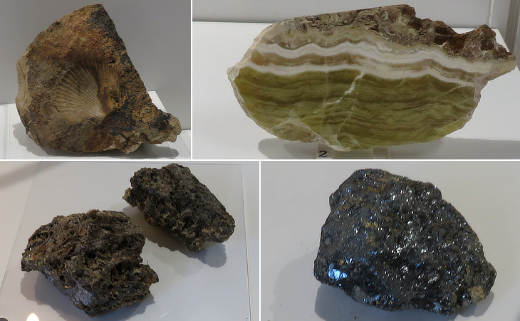
Town Museum: (above-left) fossil shell; (above-right) alabaster; (below-left) hematite, an iron oxide compound; (below-right) galena, the most important ore of lead
In addition to alunite iron ores were mined in the environs of Allumiere. In 1739 a vein of galena was discovered in an iron mine. In 5 years several mines were opened to exploit this new mineral resource and a facility for extracting lead from galena. This process required a large amount of water to actionate mills which grinded the raw material. The content of galena over time declined and in 1778 Cardinal Pallotta closed the mines and the factory.

(left) A series of XVIIth century houses for the miners; (right) fountain in the main square with the flags of "Polveriera" (gunpowder magazine) one of the four historical "rioni" of the town
Papal States - Commerce and Manufactures - The best alum known is found at Tolfa near Civita Vecchia: it was once exported in considerable quantities, but the trade has declined since the introduction of artificial alum, and the present produce is unknown. The works at Tolfa are a monopoly of the Camera, and are the only mines worked by the government. (..) At Tolfa, fifteen miles distant, are the government alumworks, farmed by the Camera, to which they yield considerable revenue; there is a paved road from the works to the port, by which the alum is brought down for shipment.
John Murray - Handbook for travellers in central Italy - 1848

(left) Parish church; (right) its main altar
In the second half of the XIXth century, significant progress in researching artificial dyes was carried out in Germany, Great Britain, Switzerland and France. This meant a significant reduction of the use of alum in the textile industry. The mines were gradually closed and in 1950 the activity totally ceased. At the time Allumiere had more than 4,000 inhabitants. Its population declined in the following years, but its proximity to the booming port of Civitavecchia provided new work opportunities.
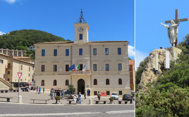
(left) Town Hall; (right) statue of the shrine of S. Maria delle Grazie
Today the protected beech forest which surrounds the town attracts many trekkers.

Views of la Rocca, the fortress
Tolfa is dominated by the ruins of a medieval fortress which once belonged to the Frangipane, a very powerful Roman family in the XIIth century. In 1799 French troops set fire to Tolfa and its fortress as the inhabitants opposed a strenuous resistance to the invaders.

(left) Walls surrounding the medieval town; (right) keep of la Rocca
The fortress was built on a veritable eagle's nest protected on three sides by steep cliffs. The fourth side was protected by walls and towers with just one small gate. After the discovery of alum the Frangipane, whose power had greatly declined, were bought out by Pope Paul II.

(left) A XVIth century house; (right) aedicule housing a sacred image on the palace of a local noble family
The inhabitants of Tolfa did not work at the mines, because these were manned with young men coming from other parts of the Papal State or from Tuscany, some of whom were pardoned of minor crimes. The mines however were part of the territory of Tolfa and they granted the town some revenues. In addition those who held managerial positions at the mines preferred to live at Tolfa. A new neighbourhood was built on a hill opposite the fortress and it still retains some interesting details.

Musei Capitolini: relief from Tomba dei Cani (Dog) (VIth century BC) - Necropolis of Pian della Conserva
The territory of Tolfa is situated between two important Etruscan towns: Tarquinia to the north and Cerveteri to the south; the tombs found near Tolfa are round tumuli, similar to those of Cerveteri. The first excavations began in the mid XIXth century and they were aimed at finding vases and possibly jewels for the antiquarian market. The reliefs depicting two hounds and a stag were donated to Musei Capitolini by Augusto Castellani. He and his brother Alessandro were goldsmiths and collectors and antiques; occasionally some of the jewels and bronzes they sold as Etruscans were of their own making.

(above) View towards the hills surrounding Lake Bracciano from la Rocca; (below) detail showing Canale Monterano, near Oriolo, the next step of this itinerary
Move to the next pages:
Archaeological Museum of Civitavecchia
Civitavecchia - Terme Taurine
Oriolo Romano and Capranica
Oriolo - Palazzo Altieri
Sutri
Bassano, Monterosi and Campagnano
Bassano - Palazzo Giustiniani
Nepi and Castel Sant'Elia
Civita Castellana
Museum of Agro Falisco at Civita Castellana

