
All images © by Roberto Piperno, owner of the domain. Write to romapip@quipo.it.
Notes:
Page revised in June 2025.

All images © by Roberto Piperno, owner of the domain. Write to romapip@quipo.it.
Notes:
Page revised in June 2025.
 Fiano, Civitella S. Paolo and Nazzano
A physical map of Italy clearly shows that the easiest and shortest route
between Florence and Rome would gain from running through the valleys of the
rivers Arno and Tiber and the so called Val di Chiana, a depression between Tuscany and Umbria.
The Romans however discarded this option and linked Rome to Florence through
Via Cassia, which crossed a hilly and even mountainous region. They did so because Val di Chiana and
to some extent the Tiber valley were subject to floods and for this reason were marshy and pretty unhealthy in some
areas.
In the XVIIIth century and in a more decisive way in the next century the marshes were
reclaimed and the flow of the Tiber brought under control. So the layout of the XIXth century
railway line did not need to climb the hills of Southern Tuscany, but
followed the three valleys.

Map of the small towns (black dots) shown in this section; the map shows also Civita Castellana and towns near Monte Soratte, along Via Flaminia and in Sabina, which are covered in other sections
From San Silvestro, at the top of Monte Soratte the Tyber with its numerous windings, is seen issuing from the woody hills beyond Magliano of Sabina, and its course may be clearly distinguished as it flows between the territory of the Capenates, and the plains below Nerola, Monte Libretti and Moricone. (..) In short, the whole Campagna di Roma, is also visible; in another direction are the castle and lake of Bracciano, and the peak of Rocca Romana; and in another the beautiful villages of Fara, Farfa, Filacciano, Torritta, Nazzano, Civitella di San Paolo, and the site of Capena.
Sir William Gell - The topography of Rome and its vicinity - 1846 ed.
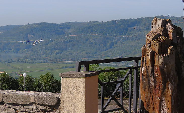
View of the highway and of the River Tiber from Torrita Tiberina
In the 1960s a highway called Autostrada del Sole (Sun Highway) linked Milan to Rome and Naples, via Florence and its layout was parallel to that of the railway. There are no major towns in the section of the Tiber valley north of Rome, but only fortified villages, so that when you reach Rome via the highway you see, on the top of the hills, towers and small castles, and you feel that they are sentinels reporting your arrival at the Eternal City.

View of some of the towns covered in this section and of Monte Soratte from Montopoli in Sabina
The medieval road to Monte Soratte remains intact to this day, following the course of the Tiber, and passing Flajanum - now called Fiano - as it goes north from Rome.
Ferdinand Gregorovius - Latian Summers (1860s) - Transl. Dorothea Roberts
The easiest way to visit these small towns (starting from Rome) is to follow Via Flaminia, reach Prima Porta and then turn right on a road which runs over the
hills next to the Tiber and is therefore called Via Tiberina.

Views of the fortress/palace of Fiano
FIANO.
A village of 490 inhabitants, a few miles southeast of Soracte, with a large turreted mansion, the property of the duke of Fiano. Some have supposed the name to have been derived from the word Fanum. There was a place, not unlike Fiano in name, (Flavina, or Flavinium) mentioned by Virgil and by Silius. And as there is nothing by which its site can be fixed, this similarity of name may be of some weight. Gell
In the 1950s the Roman shrine and town of Lucus Feroniae were discovered in the proximity of Fiano.
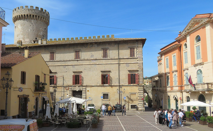
Main square and palace
The layout of Fiano shows a pattern which is common to all the locations shown in this section: there is only one fortified access to the town which is located on an elevated position which in general did not require additional defensive measures. Most of the towns belonged to the Orsini family, but were sold to other Roman families starting from the late XVIth century (the image used as a background for this page shows an Orsini coat of arms in S. Stefano, the main church of the town). In the case of Fiano the side of the fortress towards the town was modified in the XVIIth century to turn it into that of a Roman urban palace.
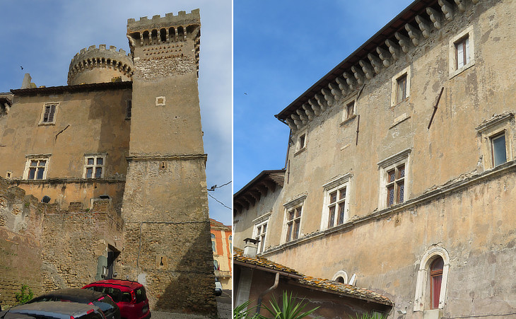
Late XVth century side with a medieval tall tower and windows similar to those of Palazzo Venezia in Rome
The Orsini family filled the annals of Rome for almost half a millennium with the deeds and names of its countless members, among whom there were popes, cardinals and there were generals of great fame. (..) The Orsini, divided over time into many family branches. They called themselves after their possessions the Orsini of Monte Giordano and of Campo di Fiore in Rome, the counts and lords of Nola in Campania, of Tagliacozzo in Abruzzo, of Gravina and Manupello, of Monterotondo, Vicovaro, S. Angelo, Pitigliano, Anguillara and Bracciano. Gregorovius
The redesign of the fortress was undertaken in 1490-1499 by Niccolò III Orsini who belonged to the Pitigliano branch of the family. He raised to fame as a condottiere. In 1495 he was hired by the Republic of Venice and in 1498 he was appointed Captain-General of the Venetian army.
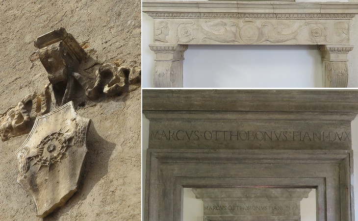
(left) Emblem of Niccolò III Orsini on the square tower (it was slightly damaged by WWII bombings); (right-above) a mantelpiece with the coat of arms of the Piccolomini family; (right-below) frames of doors with the name of Marco Ottoboni, first Duke of Fiano
The emblem with festoons of Niccolò III depicts two hands which tightly hold a pointed mastiff collar. His motto was "Prius mori quam fallere" (I would die rather than betray trust) an indication of his loyalty.
The original location of the mantelpiece is unknown, but we know that Niccolò III fought for Pope Pius II, Enea Silvio Piccolomini.
In 1690 the fiefdom of Fiano
was acquired by Pope Alexander VIII, who gave it to his nephew Marco Ottoboni with the title of duke.
The Roman family palace of the Ottoboni in Via del Corso was usually called Palazzo di Fiano.

Coats of arms and heraldic symbols of the Orsini and of the Aldobrandeschi (a rampant lion) in the fortress/palace and (below-right) in S. Stefano
During the XIVth century the Orsini of Pitigliano acquired through marriage parts of the fiefdoms of the Aldobrandeschi family at the border between the Papal State and the Republic of Siena and Niccolò III placed a reference to them in some of the many coats of arms he placed at Fiano. One of them catches the eye of the visitor because of the two roughly sculptured bears (It. orsi), the heraldic symbol of the Orsini, which can be seen in many other of their properties, e.g. at Palazzo di Monte Giordano in Rome.
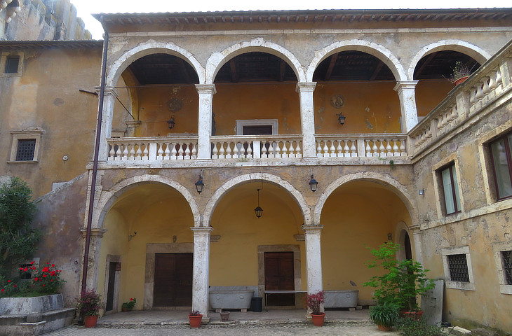
Courtyard
The medieval fortress was embellished with two fine Renaissance loggias and a pensive garden, but Niccolò III did not have many opportunities to enjoy these facilities. In 1494 the attempt by Charles VIII, King of France to seize the Kingdom of Naples led to a series of wars which saw the involvement of the Republic of Venice. In particular in 1508 Pope Julius II launched a sort of crusade to curb the power of Venice and recover some towns of the Papal State. The alliance promoted by the Pope included Louis XII of France, Emperor Maximilian I, and Ferdinand I of Spain. In April 1509 Louis left Milan at the head of his army and moved rapidly into Venetian territory. To oppose him, Venice fielded an army under the command of Niccolò III and his cousin Bartolomeo d'Alviano. The French won an important battle at Agnadello and the Papal troops occupied Ravenna. In early August, the Imperial army set out from Tyrol into Veneto. Maximilian's forces did not reach Padua until September, giving Niccolò the time to concentrate such troops as were still available to him in the city. French and Imperial artillery successfully breached Padua's walls, but the defenders managed to hold the city until Maximilian lifted the siege and withdrew to Tyrol with the main part of his army. In mid-November, Niccolò returned to the offensive; Venetian troops easily defeated the remaining Imperial forces, capturing Vicenza, Este, Feltre, and Belluno. The war continued, but in January 1510 Niccolò died at the age of 68.
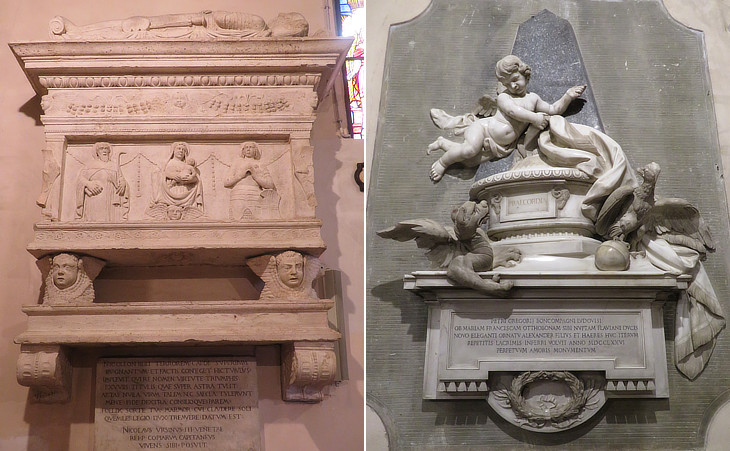
S. Stefano - Funerary monuments: (left) to Niccolò III Orsini; (right) to Pietro Gregorio Boncompagni Ludovisi Ottoboni
Niccolò III commissioned his funerary monument when he was still alive and in the inscription he listed his deeds. According to some art historians he had himself portrayed as St. George and his wife as the Virgin Mary. The design of the monument combines medieval elements (the dead in a gisant posture) with a Renaissance decoration (see some tombs at S. Gregorio al Celio).
The monument showing the heraldic symbols of the Boncompagni (a dragon) and of the Ottoboni (a double-headed eagle) was erected in 1776 by the heirs of Pietro Gregorio Boncompagni who by marrying Maria Francesca Ottoboni, the only daughter of Marco Ottoboni, first Duke of Fiano, created a new Roman noble family (see their palace in Rome). At the time the use of heraldic symbols in the design of funerary monuments was popular in Rome (see an extremely elaborate example at S. Maria del Popolo).
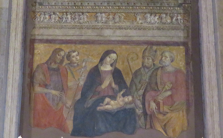
S. Stefano - Main altar: The Virgin Mary and Saints John the Baptist, Stephen, Blaise and Peter
In 1960 the roof of the church collapsed and the interior was largely modernized in the following years. It retains however some interesting works of art. The fine painting of the main altar was traditionally attributed to Antonio Massaro il Pastura, a painter from Viterbo (see an altarpiece by him at Canino). New studies suggest it might be a work by Cola dell'Amatrice, a painter, sculptor and architect who is best known for having designed S. Bernardino at L'Aquila.
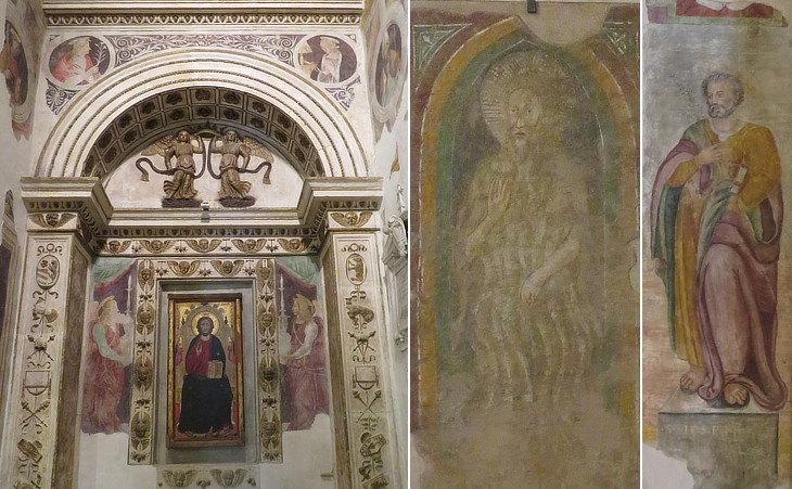
S. Stefano: (left) Cappella dell'Annunciazione; (centre) a hermit saint, a late XIIIth century painting from S. Maria ad Pontem; (right) a XVIth century fresco portraying a saint
Niccolò III commissioned an elegant chapel dedicated to the Annunciation. The gilded decoration is typical of the end of the XVth century and it can be seen in several churches in Rome, e.g. at S. Maria in Trastevere and at S. Pietro in Vincoli. The altarpiece is an earlier work (late XIVth century) based on a holy image of Christ at the Lateran; its style shows some similarities to a triptych at Bracciano.

(left) Santa Maria ad Pontem, a deconsecrated church outside the town; (centre) tower of the walls; (right) pomegranates
A stroll through the streets of Fiano shows other aspects of the past, including ripe pomegranates. This fruit was very popular in the past and because of its many allegorical meanings, it appeared in a variety of paintings: in the hands of an Austrian emperor to represent the diverse nations united by the empire or in that of Infant Jesus as a symbol of chastity and resurrection.

The Tiber valley seen from the road between Fiano and Civitella San Paolo
Civitella di San Paolo.
A village near Fiano, with 582 inhabitants. It is one of those seen from the summit of Mount Soracte. Gell
The reference to St. Paul in the name of this small town is not due to religious fervour, but to the fact
that Civitella belonged to Monastero di S. Paolo fuori le Mura as recorded in a bull by Pope Gregory VII in 1081.

Fortress and gate of Civitella S. Paolo
The fortress has almost entirely retained its medieval appearance. A drawbridge was for centuries the only access to the fortress and the town. The decoration of the gate with the symbol of St. Paul was added in the year 1800.

(left) Inner side of the fortress; (right) Porta Capena
During the XVth century the small town knew a period of growth and it was enlarged and provided with a second gate at a lower level than that of the fortress.

(left) Coat of arms of Monastero di S. Paolo; (centre/right) Roman funerary inscriptions some of which were found in 1890 between Civitella and Nazzano
Another Etruscan city which played a prominent part in the early history of Rome, was Capena. It is first mentioned hy Livy in his account of the first Veientine war, when it united with Falerii in assisting Veii, then beleaguered by the Romans. (..) That Capena continued to exist as late as the time of Aurelian, is proved by scattered notices in ancient writers and by inscriptions. (..) When interest was again awakened in the antiquities of Italy, Capena was sought for, but long in vain. Cluver placed her site at Civitella San Paolo, not far from the Tiber; Holstenius, at Morlupo.
George Dennis - The cities and cemeteries of Etruria - 1878
Leprignano, another small nearby town which belonged to Monastero di S. Paolo was renamed Capena in 1933. The courtyard of the fortress is a sort of open air museum showing ancient
Roman reliefs and inscriptions.
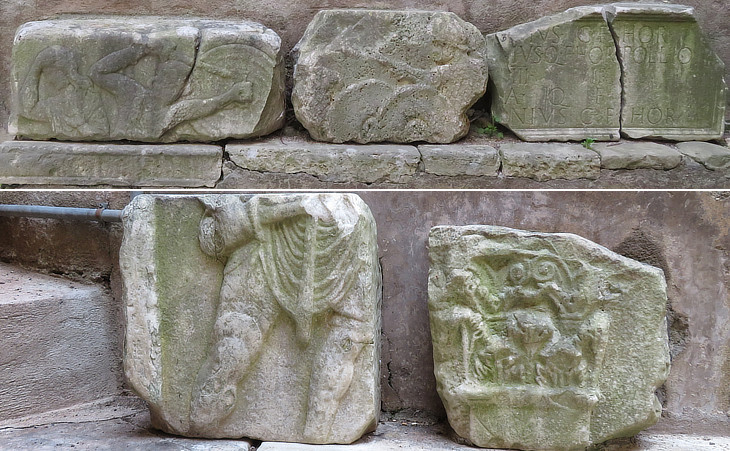
Reliefs and other Roman stones
Two fragments of a relief seem to portray a fight between gladiators. In 2007 very elaborate and complex funerary reliefs depicting such fights were discovered in the countryside near Civitella and Fiano.
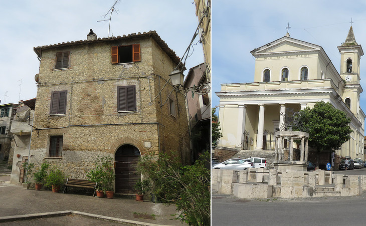
(left) A piazza inside the historical part of the town; (right) S. Giacomo Maggiore
Today very few people live inside the walls. The majority of the houses are aligned along the road which branches off Via Tiberina and leads to a large square with the parish church. It was designed by Francesco Vespignani in 1868. His father Virgilio was the Roman leading architect during the last years of the Papal State and the church calls to mind S. Maria della Misericordia in the main cemetery of Rome.
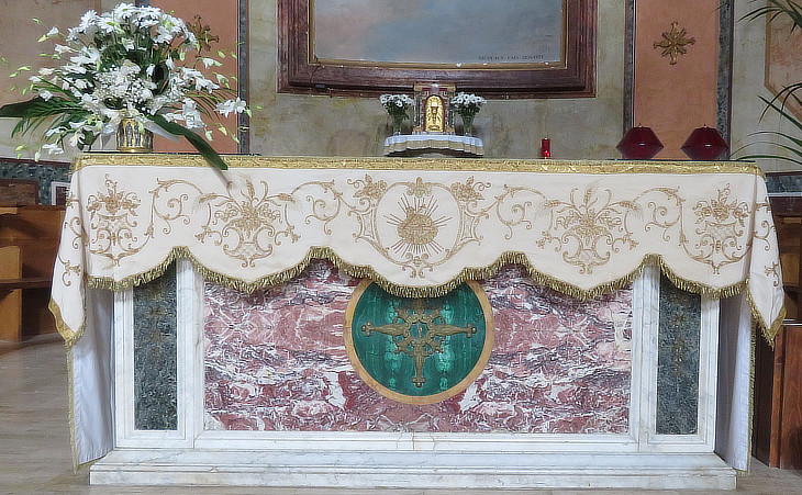
S. Giacomo Maggiore: marble altar from S. Elena dei Credenzieri, a small church of Rome which was pulled down in 1887

View of Nazzano from the west
Nazzano is located on a hill directly overlooking the highway and even the most absent-minded driver cannot fail to notice its elegant tall fortress.
Here again there is only one (fortified access) to the minuscule town and a drawbridge led to the fortress. Nazzano belonged for centuries to Monastero di S. Paolo fuori le Mura.
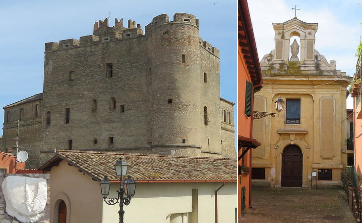
(left) Southern side of the Fortress: (inset) coat of arms of Monastero di S. Paolo; (right) S. Maria Consolatrice
Nazzano. A large and well situated village, of five hundred and thirty inhabitants, situated on the pretty wooded hills on the banks of the Tyber opposite the mountains of Sabina. It is seen from the top of Soracte, and also from Fiano. Gell
The parish church was built in the XVth century, but it was enlarged and redesigned in the early XVIIth century. It houses the relics of Saint Antimo, a IVth century martyr who was drowned in the Tiber and to whom in the Xth century a church was dedicated on a hill adjoining that of Nazzano. An Antimo Orsini was the lord of nearby Morlupo at the end of the XVIth century.
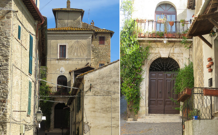
Palazzo Crostarosa, at the foot of the hill of S. Antimo: (left) sundial; (right) portal
In labore vultus nomine quaesivi tu vero non nobis sed nomini tuo da gloriam. The inscription includes a quote from St. Augustine and the beginning of a Christian hymn (Not unto us, O Lord, not unto us, but to thy name give the glory). It was most likely dictated by Mons. Pietro Crostarosa, Dean of S. Maria Maggiore and secretary of the Pontifical Commission of Archaeology at the end of the XIXth century. The Crostarosa were a family from Pizzoli in the Vale of L'Aquila who established themselves in Rome in 1821.

View of the Tiber from Nazzano
Nazzano enjoys very fine views over the many twists and turns of the Tiber. At the foot of the hill Nazzano had a small river landing point from which in the past vegetables and fruit were shipped to Porto di Ripetta.

